|
The Dead Sea could more properly be described as a large salt lake at
the south of the Jordan River below the Sea of Galilee.
It does not appear to have been called "the Dead Sea"
until more than a century after the time of Christ. In the Old
Testament it is referred to as "the Salt Sea", "the
Sea of the Arabah", and "the Eastern Sea". While the
New Testament does not contain any mention of it, the first century
historian Josephus speaks of it under the name "Lake
Asphaltitus". The Arabic name "Bahr Lilt" means
"Sea of Lot" showing their historic recognition of the
events surrounding Lot's life and the cities of
the plain.
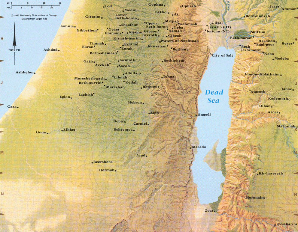
The earliest scriptural reference to the Dead Sea is found in
Genesis, where the text references it as the Salt Sea. Specifically
the valley extending along the Dead Sea, between the water and the
five infamous cities on its central to south eastern side, is the
stated location of a battle.
Genesis 14:3 All these latter kings joined forces in the Valley of
Siddim (the Salt Sea). (NIV)
Genesis 13:10 suggests that the valley and plain region surrounding
the Dead Sea was much more fertile in the time prior to the
Destruction of Sodom and Gomorrah. Certainly, following God's
judgment on these cities, the land became desolate - sometime that is
generally still true to this day even though modern technologies are
being used for limited irrigation in a few places.
See our article on the five cities of the plain
for more details regarding the Dead Sea region at that time, plus a
number of photos of the Dead Sea today.
A
view from the Jordanian side on the southern part of the northern basin
The Dead Sea is the lowest point on earth, approximately 1400 feet
(427 meters) below sea level. The level of the Sea has fluctuated
widely throughout history, the greatest decline ever being in the
last few decades. (For this reason, relatively modern sources will
quote the Sea as being up to 120 feet, or 37 meters, higher than the
approximate level we cited). The Sea is approximately 50 miles (80
km) in length, having a maximum width of about 10 miles (16
kilometers). It is divided into northern and southern sections by a
promontory known as the el-Lisan (meaning "the tongue")
which virtually divides the sea when the water is at the low levels
of today. The northern basin is much deeper than the smaller southern
basin (about 25% of the lake) which is 30 feet (9 meters) or less in
depth. In fact, currently, if it was not because of water pumped from
the northern basin, the southern would likely be completely dried up.
The Dead Sea, as a whole, is at its lowest level in history and is in
danger of being depleted. Jordan and Israel are actively discussing a
project to re-flood the Dead Sea either from the Red Sea or the Mediterranean.
The primary source of water for the Dead Sea was once the Jordan
River. Additional water came from sources such as Wadi Kerak, the
Arnon, the Zered, springs at En-Gedi, Qumran, and the thermal springs
Callirhoe. Occasional floods from winter rains also contribute, but
the region is very dry averaging less than 2 inches (5 centimeters)
per year. Today, most fresh water from the wadis, rivers, and springs
has been diverted for irrigation and drinking purposes. Even the
Jordan is barely a shadow of its former volume as it enters the Dead Sea.
See our article on En Gedi for more details
on this important ancient Dead Sea area.
The Dead Sea historically was used as a distinctive boundary marker,
even as today it divides the modern countries of Jordan and Israel.
Consider these passages from the time of the exodus out of Egypt and
the division of the land to the tribes.
Numbers 34:1-3 The Lord said to Moses, 2 "Command the Israelites
and say to them: 'When you enter Canaan, the land that will be
allotted to you as an inheritance will have these boundaries: 3
"'Your southern side will include some of the Desert of Zin
along the border of Edom. On the east, your southern boundary will
start from the end of the Salt Sea (NIV, see also verse 12)
Deuteronomy 3:16-17 But to the Reubenites and the Gadites I gave the
territory extending from Gilead down to the Arnon Gorge (the middle
of the gorge being the border) and out to the Jabbok River, which is
the border of the Ammonites. 17 Its western border was the Jordan in
the Arabah, from Kinnereth to the Sea of the Arabah (the Salt Sea),
below the slopes of Pisgah. (NIV)
Joshua 3:15-17 Now the Jordan is at flood stage all during harvest.
Yet as soon as the priests who carried the ark reached the Jordan and
their feet touched the water's edge, 16 the water from upstream
stopped flowing. It piled up in a heap a great distance away, at a
town called Adam in the vicinity of Zarethan, while the water flowing
down to the Sea of the Arabah (the Salt Sea) was completely cut off.
So the people crossed over opposite Jericho. 17 The priests who
carried the ark of the covenant of the Lord stood firm on dry ground
in the middle of the Jordan, while all Israel passed by until the
whole nation had completed the crossing on dry ground. (NIV)
Joshua 12:2-3 Sihon king of the Amorites, who reigned in Heshbon. He
ruled from Aroer on the rim of the Arnon Gorge - from the middle of
the gorge - to the Jabbok River, which is the border of the
Ammonites. This included half of Gilead. 3 He also ruled over the
eastern Arabah from the Sea of Kinnereth to the Sea of the Arabah
(the Salt Sea), to Beth Jeshimoth, and then southward below the
slopes of Pisgah. (NIV)
Joshua 15:1-5b The allotment for the tribe of Judah, clan by clan,
extended down to the territory of Edom, to the Desert of Zin in the
extreme south. 2 Their southern boundary started from the bay at the
southern end of the Salt Sea, 3 crossed south of Scorpion Pass,
continued on to Zin and went over to the south of Kadesh Barnea. Then
it ran past Hezron up to Addar and curved around to Karka. 4 It then
passed along to Azmon and joined the Wadi of Egypt, ending at the
sea. This is their southern boundary. 5 The eastern boundary is the
Salt Sea as far as the mouth of the Jordan. (NIV, also see Joshua
18:11-20 for Benjamin's borders which touched the Salt Sea).
Deuteronomy 3:16-17 But to the Reubenites and the Gadites I gave the
territory extending from Gilead down to the Arnon Gorge (the middle
of the gorge being the border) and out to the Jabbok River, which is
the border of the Ammonites. 17 Its western border was the Jordan in
the Arabah, from Kinnereth to the Sea of the Arabah (the Salt Sea),
below the slopes of Pisgah. (NIV, see also Deuteronomy 4:49)
Much later, the prophets Ezekiel and Joel refer to the Dead Sea as
the Eastern Sea, in the case of Joel it is in contrast to the
Mediterranean which calls the Western Sea. These too are given as
geographical boundaries.
Ezekiel 47:18 "On the east side the boundary will run between
Hauran and Damascus, along the Jordan between Gilead and the land of
Israel, to the eastern sea and as far as Tamar. This will be the east
boundary. (NIV)
Joel 2:20 'I will drive the northern army far from you, pushing it
into a parched and barren land, with its front columns going into the
eastern sea and those in the rear into the western sea. (NIV)
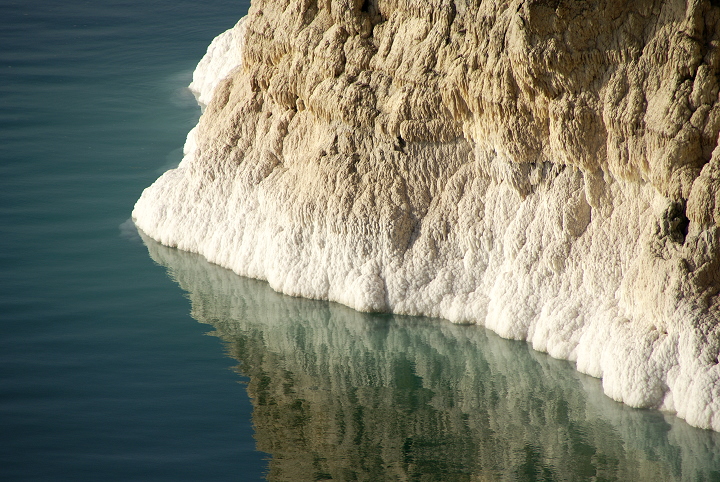
A
view from the Jordanian side on the southern part of the northern
basin. Notice the salt buildup as the water has receded.
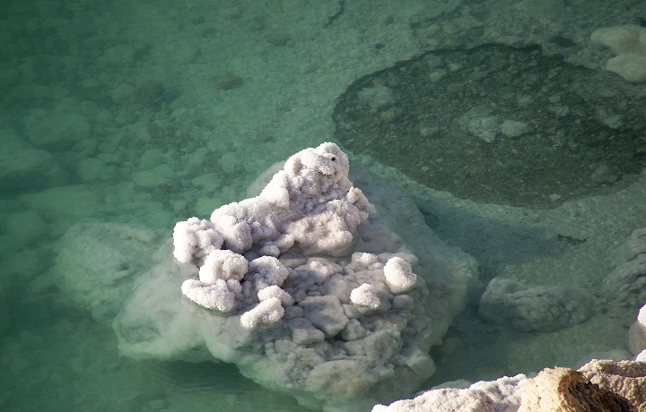
Everything
under the water is encrusted in salt.
|
|
The Dead Sea is not directly mentioned in the New Testament, though
it certainly had economic and strategic importance at that time.
During the Roman period it appears that the Sea was also at a low
level as there are traces of a Roman road that was built across the
el-Lisan peninsula. The description of Josephus, written in the
immediate post biblical period, is worth considering, though most
scholars find his dimensions suspect (and may not include both basins).
The nature of the lake Asphaltitis is also worth describing. It is,
as I have said already, bitter and unfruitful. It is so light [or
thick] that it bears up the heaviest things that are thrown into it;
nor is it easy for any one to make things sink therein to the bottom,
if he had a mind so to do. Accordingly, when Vespasian went to see
it, he commanded that some who could not swim should have their hands
tied behind them, and be thrown into the deep, when it so happened
that they all swam as if a wind had forced them upwards. Moreover,
the change of the color of this lake is wonderful, for it changes its
appearance thrice every day; and as the rays of the sun fall
differently upon it, the light is variously reflected. However, it
casts up black clods of bitumen in many parts of it; these swim at
the top of the water, and resemble both in shape and bigness headless
bulls; and when the laborers that belong to the lake come to it, and
catch hold of it as it hangs together, they draw it into their ships;
but when the ship is full, it is not easy to cut off the rest, for it
is so tenacious as to make the ship hang upon its clods till they set
it loose with the menstrual blood of women, and with urine, to which
alone it yields. This bitumen is not only useful for the caulking of
ships, but for the cure of men's bodies; accordingly, it is mixed in
a great many medicines. The length of this lake is five hundred and
eighty furlongs, where it is extended as far as Zoar in Arabia; and
its breadth is a hundred and fifty. The country of Sodom borders upon
it. It was of old a most happy land, both for the fruits it bore and
the riches of its cities, although it be now all burnt up. It is
related how, for the impiety of its inhabitants, it was burnt by
lightning; in consequence of which there are still the remainders of
that Divine fire, and the traces [or shadows] of the five cities are
still to be seen, as well as the ashes growing in their fruits; which
fruits have a color as if they were fit to be eaten, but if you pluck
them with your hands, they dissolve into smoke and ashes. And thus
what is related of this land of Sodom hath these marks of credibility
which our very sight affords us. (Josephus: Wars of the Jews 4.8.4)
Fragments of the works of the early church father Sextus Julius
Africanus provide more detail about the Dead Sea from the early third
century. Africanus, who called himself a native of Jerusalem and
later lived at Emmaus, in his Chronography (History of the World,
written circa 221 A.D.), chapter 9, wrote:
In Canaan, Abraham's shepherds and Lot's contended with each other;
and with mutual consent they separated, Lot choosing to dwell in
Sodom on account of the fertility and beauty of the land, which had
five cities, Sodom, Gomorrah, Adama, Seboim, Segor, and as many
kings. On these their neighbors the four Syrian kings made war, whose
leader was Chodollogomo king of Aelam. And they met by the Salt Sea,
which is now called the Dead Sea. In it I have seen very many
wonderful things. For that water sustains no living thing, and dead
bodies are carried beneath its depths, while the living do not
readily even dip under it. Lighted torches are borne upon it, but
when extinguished they sink. And there are the springs of bitumen;
and it yields alum and salt a little different from the common kinds,
for they are pungent and transparent. And wherever fruit is found
about it, it is found full of a thick, foul smoke. And the water acts
as a cure to those who use it, and it is drained in a manner contrary
to any other water. And if it had not the river Jordan feeding it
like a shell, and to a great extent withstanding its tendency, it
would have failed more rapidly than appears. There is also by it a
great quantity of the balsam plant; but it is supposed to have been
destroyed by God on account of the impiety of the neighboring people.
(from Ante-Nicene Fathers, Volume 6, PC Study Bible formatted
electronic database Copyright © 2003, 2006 by Biblesoft, Inc.
All rights reserved.)
A few hundred years later, circa 527-565 A.D, the Madaba
map shows the Dead Sea, complete with a fishing boat. Though nothing
could live in the Dead Sea because of its' salt levels, fish often
came into the Dead Sea from the Jordan (and perhaps other
tributaries), subsequently died and were fished out as they floated
to the top. This practiced continued into modern times until water
levels and diversion of water made it impossible.
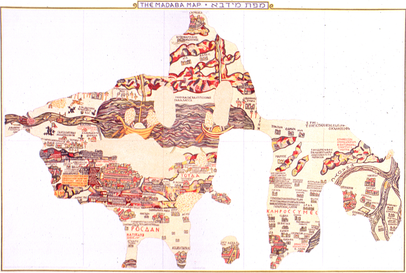
The
Madaba mosaic map. Click on map for closer view or for more details
on Madaba overall click here.
The period of the Muslim conquests in the 7th century also saw an
increase in precipitation and a decrease in irrigation, both leading
to an overall expansion of the Dead Sea - notwithstanding periodic
fluctuations - that lasted into this past century. The salinity of
the water has been increasing with the modern decline of the Dead
Sea, estimates range from 25% to 33%. Contrast this to the oceans of
the world which range from 4% to 6%. The southern basin has a higher
evaporation rate so it tends to be saltier, as are samples taken from
a greater depth (below 130 ft/40 meters) in the northern basin where
the water is highly saturated. Numerous minerals are also found in
the water including: potassium, magnesium, gold and bromide salts;
some of which are currently being harvested by both Jordan and Israel
(notably potash). The Dead Sea even in ancient times was known for
its medicinal and health properties. Today, besides local health spas
and mud baths, a host of health and beauty products are manufactured
from Dead Sea materials on both sides of the Sea.
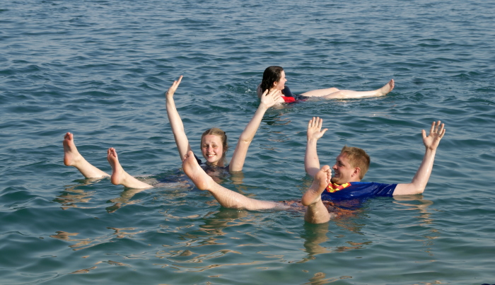
As a final note, to answer some commonly asked questions, the water
feels oily to the touch, yet leaves a crust of salt on your skin as
it dries. Swimming is functionally impossible in the water as its
buoyancy suspends you at the surface. In fact, in the northern basin,
I have actually stood upright in the water without touching the
bottom, suspended with my shoulder and most of my upper arms
completely out of the water. Having taken an accidental drink of
water in the southern basin, I can assure you that you shouldn't. The
water is disgusting, if not nauseating in its taste; one not readily
removed from your mouth even with repeated rinsing of fresh water. |